
It is inferred that in the solar system water in liquid form exists only on the Earth. Since 2/3 of the Earth is covered by water, when you look at the Earth from outer space, it looks like a blue ball. The Earth is also called the blue planet. 97% of the water on the Earth is saline; pure water is only 3%, out of which 2.67% cannot be directly utilized. Water that can be directly used is only 0.33%. It is estimated that the total quantity of water in the Earth is 138.6 million cubic kilometer. This is found in the oceans, on the land and in the atmosphere. Water in the ocean is saline. The pure water exists in the various water bodies on the Earth (rivers, lakes etc.), in the glaciers and in the atmosphere in the form of water vapor. The total volume of water on the Earth is almost constant. The water in the sea, rivers and lakes, and the water absorbed by the plants get heated up by the sun and reach the atmosphere. This water which evaporates into the air, condenses and falls back on the Earth in the form of rain, snow etc.. Thus water is always in a cyclic movement and this is called water cycle. tis is due to this process the quantity of water on the Earth remains constant. Pure water is distributed on the Earth at the sources of surface water like the rivers and lakes and as underground water.


Rain plays an important role in replenishing these water bodies. Rivers are the most important among the sources of surface water. The land use practices in an area significantly influence the regular flow of water in the river. If the river takes its origin from mountains and hill slopes where there are dense forests, the flow of water can be seen in the river throughout the year. But if the streams originate on slopes where there are plantations or mixed crops, it can be seen that the flow of water is more during monsoons and less in summer. The rivers can be divided into two on the basis of their flow; perennial rivers and non perennial rivers. Rivers that flow throughout the year are called perennial rivers. Rainfall and melting snow are the main sources of water for the perennial rivers. There are perennial rivers which depend solely on rain. These are the rivers which take their origin in the regions near the equator where there is rainfall in almost all the days in a year. Examples of these are the Amazon, the Nile and Congo rivers. The only river that crosses the equator twice is the Congo. This is a perennial river that rises from the rain forests of Africa. There are many perennial rivers that get rain water during the rainy season and melted snow during summer. Examples of these are rivers like the Indus, the Ganga and the Brahmaputra which rise from the Himalayas. All the rivers in India except those which take their origin in the Himalayas have a regular flow during monsoon and are lean in summer. This is because in summer most of their tributary streams run dry. A part of the rain that fall on the Earth seeps into the Earth. In some areas, the water dries up very quickly after rain. But in paddy fields and marshes, this water remains stagnant for days. This is because the water does not seep into the Earth at the same rate everywhere. The factors which influence this are:
- The differences in the composition of soil particles.
- The topography of the land.
- Presence of organic matter etc.

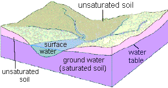
When the water filters from the top soil inwards, it is called filtration. The water thus filters down travels due to the gravitational pull and becomes a part of the underground water. This is called percolation. Water not only filters down through the soil but also through the cracks in rocks. There is a difference in the rate of percolation, depending on the composition of the soil and rock. This is a major factor that determines the quantity of subsurface water. The water that infiltrate thus, collects in the layers of rocks. These are called aquifers. A part of the water that collects in this way reaches the rivers and ponds as underground flow. The property of rocks that can contain the water is called porosity. When the soil and rocks are able to let the water drain it is called Permeability. It is not necessary for a porous rock to have permeability. For example, clay is porous but not permeable. The subsurface water is generally distributed in two main zones. The zone which is just below the surface of Earth is the unsaturated zone, which is characterized by loose soils and disintegrated rocks. Further down, which is the zone that is fully saturated with water. This is the saturated zone. The upper portion of this zone is called the water table. The water table drops due to excessive use of underground water. This is found in areas where the rainfall is comparatively less. The rate of consumption of underground water is higher than that at which it is replenished, it can cause the water table to drop. In the same way, when more sand is mined from rivers, the water table is seen to fall. Another reason for the drop of water table is the reclamation of wetlands. Wetlands comprise marshy lands, pods or lakes where the water stagnates or flows into streams, rivers, canals and the areas where at low tide, sea water is less than 6 meters high. Wetlands are areas between rivers and land having the properties of both. Small and big ponds, dams, reservoirs, rivers, streams, plains which has gone underwater due to changing seasons, islets, areas covered by mangroves, marshes, low-lying paddy fields and other areas which hold water for at least six months in a year are all wetlands.

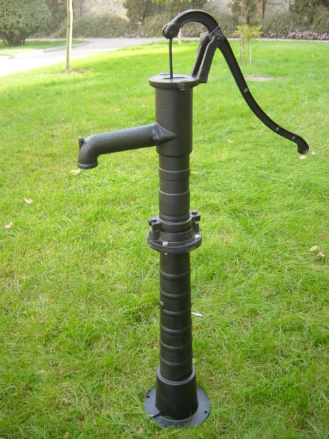
The vegetative cover of an area helps to enrich the level of subsurface water and increases in the flow of water in the river. The rain that falls on the vegetative cover loses its force as reaches the top soil. The humus content in the top soil absorbs the water and helps it to seep slowly into the Earth. In this way, the underground water table gets enriched. But in places where there is sparse vegetation, the rain falls with greater force on the Earth. As it does not get absorbed, it becomes an overland flow and causes soil erosion. When the topsoil is being eroded it paves way for the formation of rills which, in turn, leads to the exposure of rock layers and results in the deterioration of the land. We must have seen wells and tube wells. Well water is the water from the saturated zone. The shallow tube wells that are dug in sandy areas are called filter point of wells. These types of wells may exist in some your localities. In alluvial soil, where the soil is not consolidated the Earth is dug and tubes are placed in them to make tube wells. 10 to 30 centimeters wide tubes are used to make them and according to the nature of the land they go to a depth of 15 to 150 meters. At times when water is sandwiched between two impermeable rock layers, the rock is drilled through to reach the water. These are artesian wells. In some areas the saturated zone lies close to the Earth's surface. In such places water flows out continuously; they are called springs. In deserts, the wind blows the sand away. If the process strengthens, big depressions are created. When the depression deepens and touches the water table an oasis is formed. Jaisalmer lake in Rajasthan is an example of such an oasis.
The water that collects in the rock layers, sometimes flows out through cracks in the rocks. They are usually seen on mountain slopes. They are also called springs. In the volcanics regions the magma causes the underground water to get heated and hence hot water comes out continuously to the surface as hot springs. In some areas, instead of flowing out continuously the hot water comes out with force at intervals. These are called geysers. Parched agricultural lands and journeys to several kilometers in search of water are a common sight in many parts of the world. When the population increases, the per capita availability of water decreases and it causes water shortage. Hence is a greater need to conserve the available water. There is no other resource that has so many uses as water. Water sources are used to a large extend for industrial purposes. Industries which need more water are concentrated near water bodies. But when these industries are concentrated in those regions where the water is scarce, it will lead to the overexploitation of the water resource. In such situations effective methods are to be adopted for the reuse of this resource. There are industries which make use of water itself as the raw material. History provides a lot of evidences from ancient time for the hardships which man faced for the misuse of water from ancient times. The reason for Mesopotamia to become a desert was the unplanned urbanization of the agricultural country and its poor drainage system. Deforestation aggravated this situation. The fall of the Harappan civilization is mainly due to the exploitation of the river Indus. Too much water was used for agriculture and construction. When the river changed its course, the scarcity of water became intense. When trees in the forest were cut down, rainfall decreased and drought became severe and consequently cultivation came to a standstill.
No comments:
Post a Comment