Translate

Search This Blog

Sunday 28 December 2014

Increase Your Internet Speed Using Command Prompt

It's very easy to increase your Internet speed using Command Prompt or CMD
Just Follow My Steps


1)Go to Start than run cmd as Administator
       

         than a command window will appear


2)type 'CD/'


than press Enter

3)type 'netsh int tcp show global'


than press enter


4)type 'netsh int tcp set global chimney=enabled'


than press enter


5)type 'netsh int tcp set global autotuninglevel=normal'


than press enter


6)type 'netsh int tcp set global congestionprovider=ctcp'


than press enter


7)let's check whether all have been done
           for that type 'netsh int tcp show global'


than press enter and check all those steps


                        done!!!!!!!!!


                                                               OR 


WATCH THIS VIDEO


Android USSD Codes


USSD codes are very helpful to know information about the phone, android, etc.

Some of the android USSD codes are given below.

  • IMEI Number                    -*#06#
  • Software Version               -*#44336#
  • Ram Version                      -*#*#3264#*#*
  • H/W Version                      -*#2222#
  • Firmware Version              -*#1234#
  • SW & HW Info                  -*#12580*369#
  • Service Mode                     -*#197328640#
  • Audio Mode                       -*#0673#
  • Bluetooth Device Address -*#232337#
  • General Test Mode             -*#0*#
  • Melody Test Mode             -*#0289#
  • Ciphering Info                    -*#32489#
  • Bluetooth Test Mode          -*#232331#
  • WLAN Test Mode              -*#232339#
  • Phone/Pda/CSC Info           -*#*#999#*#*
  • Melody Test Mode              -*#0289#
  • Ciphering Info                     -*#32489#
  • Audio Test Mode                 -*#0673#
  • Vibration Motor Test           -*#0842#
  • General Test Mode              -*#0*#
  • Bluetooth Device Address   -*#202337#
  • ADC Reading                       -*#0228#
  • WLAN Test Mode                -*#232339#
  • Bluetooth Test Mode            -*#232331#
  • Real Time Clock Test           -*#0782#
  • Bluetooth Test                       -*#*#232331#*#*
  • GPS System Test                   -*#*#1472365#*#*
  • Power Button Change           -*#*#7594#*#*
  • Touch Screen Test                 -*#*#2664#*#*
  • Quick Test Menu                   -*#7353#
  • Proximity Sensor Test Mode -*#0588#
  • Proximity Sensor Test           -*#*#0588#*#*

Friday 26 December 2014

Atmospheric Pollution

When there is a change in the atmosphere it greatly affects the environment. If the presence of any gas becomes a threat to health whether in higher or smaller amounts and if new gases are added to the atmosphere, it is called Air pollution. Several harmful gases and dust particles reach the atmosphere through different ways.

Acid Rain


Due to the atmospheric pollution, a lot of acid particles get mixed up with rain water and falls as acid rain. The carbon dioxide in the air mixes with the water vapor and carbonic acid is formed. The water vapor and acids that are mixed in the atmosphere, fall as rain and snow on the Earth. When the quantity of carbon dioxide in the atmosphere increases, the intensity of the acid rain also increases. Acid rain causes a number of problems. Continuous acid rain pollutes the water. When the drinking water gets polluted with acid, it causes problems for the kidneys, weakening of bones and affects the growth of children. Continuous acid rain stunts the growth of plants. It can lead to the deterioration of agricultural sector and even threaten food security.

Greenhouse Effect


The gases like  carbon dioxide and methane, and eater vapor found in the atmosphere play an important role in regulating the temperature. These are the greenhouse gases. The glass houses used in cold regions to grow plants are known as greenhouses. The temperature in these houses is usually higher than the outside temperature. This is because the glass allows the incoming short wave radiation of the sun to enter without any obstruction and prevents the escape of the outgoing long wave radiation. So the temperature in the glass houses remains high. In this way the atmosphere with the help of greenhouse gases retain the temperature, it is called the greenhouse effect. When the amount of greenhouse gases increases, the amount of heat absorbed by them also increases which in turn rises the atmospheric temperature.

Global Warming


Due to the industrialization the amount of greenhouse gases in the atmosphere has increased. The urbanization and the increase in the number of vehicles have also added to this. Due to the influx of carbon dioxide and methane in the atmosphere the temperature on the Earth increases. If the atmospheric pollution increases, the greenhouse gases will increase and so also the atmospheric temperature. The increase in the average temperature in the atmosphere near the surface of the Earth is global warming.

Ozone Depletion


Comparatively, very little amount of ozone is present in the atmosphere. It is from about 18 to 55 kilometers above the Earth's surface in the stratosphere. This region where ozone is present is called the ozone umbrella or ozone layer. This ozone layer filters the dangerous ultraviolet rays of the sun and prevents them from reaching the Earth. If the ozone in this layer decreases, the ultraviolet rays of the sun will fall on the Earth. This will be harmful to all living things including man. The sprays, paints and other articles we use release Chloroflurocarbon (CFC) and these gases are agents which cause destruction of the ozone layer. The depletion caused to the ozone layer is called the ozone hole. Studies reveal that the density of the ozone in the atmosphere in the polar and mid latitudinal regions has decreases. As a result, the amount of ultraviolet rays from the sun that reach the Earth's surface has also increased. The problems caused by the ozone depletion are change in climate, destruction to agriculture and forests, increase in incidence of skin cancer, diseases like cataract and blindness to eyes and the destruction of the organic linkages in our food chain.

Ozone day

The world celebrates September 16th as Ozone Day. It is to convey the importance of protecting the ozone layer that this day is celebrated.

Saturday 20 December 2014

Water - The Elixir of Life

It is inferred that in the solar system water in liquid form exists only on the Earth. Since 2/3 of the Earth is covered by water, when you look at the Earth from outer space, it looks like a blue ball. The Earth is also called the blue planet. 97% of the water on the Earth is saline; pure water is only 3%, out of which 2.67% cannot be directly utilized. Water that can be directly used is only 0.33%. It is estimated that the total quantity of water in the Earth is 138.6 million cubic kilometer. This is found in the oceans, on the land and in the atmosphere. Water in the ocean is saline. The pure water exists in the various water bodies on the Earth (rivers, lakes etc.), in the glaciers and in the atmosphere in the form of water vapor. The total volume of water on the Earth is almost constant. The water in the sea, rivers and lakes, and the water absorbed by the plants get heated up by the sun and reach the atmosphere. This water which evaporates into the air, condenses and falls back on the Earth in the form of rain, snow etc.. Thus water is always in a cyclic movement and this is called water cycle. tis is due to this process the quantity of water on the Earth remains constant. Pure water is distributed on the Earth at the sources of surface water like the rivers and lakes and as underground water.


 Rain plays an important role in replenishing these water bodies. Rivers are the most important among the sources of surface water. The land use practices in an area significantly influence the regular flow of water in the river. If the river takes its origin from mountains and hill slopes where there are dense forests, the flow of water can be seen in the river throughout the year. But if the streams originate on slopes where there are plantations or mixed crops, it can be seen that the flow of water is more during monsoons and less in summer. The rivers can be divided into two on the basis of their flow; perennial rivers and non perennial rivers. Rivers that flow throughout the year are called perennial rivers. Rainfall and melting snow are the main sources of water for the perennial rivers. There are perennial rivers which depend solely on rain. These are the rivers which take their origin in the regions near the equator where there is rainfall in almost all the days in a year. Examples of these are the Amazon, the Nile and Congo rivers. The only river that crosses the equator twice is the Congo. This is a perennial river that rises from the rain forests of Africa. There are many perennial rivers that get rain water during the rainy season and melted snow during summer. Examples of these are rivers like the Indus, the Ganga and the Brahmaputra which rise from the Himalayas. All the rivers in India except those which take their origin in the Himalayas have a regular flow during monsoon and are lean in summer. This is because in summer most of their tributary streams run dry. A part of the rain that fall on the Earth seeps into the Earth. In some areas, the water dries up very quickly after rain. But in paddy fields and marshes, this water remains stagnant for days. This is because the water does not seep into the Earth at the same rate everywhere. The factors which influence this are:
  • The differences in the composition of soil particles.
  • The topography of the land.
  • Presence of organic matter etc.
When the water filters from the top soil inwards, it is called filtration. The water thus filters down travels due to the gravitational pull and becomes a part of the underground water. This is called percolation. Water not only filters down through the soil but also through the cracks in rocks. There is a difference in the rate of percolation, depending on the composition of the soil and rock. This is a major factor that determines the quantity of subsurface water. The water that infiltrate thus, collects in the layers of rocks. These are called aquifers. A part of the water that collects in this way reaches the rivers and ponds as underground flow. The property of rocks that can contain the water is called porosity. When the soil and rocks are able to let the water drain it is called Permeability. It is not necessary for a porous rock to have permeability. For example, clay is porous but not permeable. The subsurface water is generally distributed in two main zones. The zone which is just below the surface of Earth is the unsaturated zone, which is characterized by loose soils and disintegrated rocks. Further down, which is the zone that is fully saturated with water. This is the saturated zone. The upper portion of this zone is called the water table. The water table drops due to excessive use of underground water. This is found in areas where the rainfall is comparatively less. The rate of consumption of underground water is higher than that at which it is replenished, it can cause the water table to drop. In the same way, when more sand is mined from rivers, the water table is seen to fall. Another reason for the drop of water table is the reclamation of wetlands. Wetlands comprise marshy lands, pods or lakes where the water stagnates or flows into streams, rivers, canals and the areas where at low tide, sea water is less than 6 meters high. Wetlands are areas between rivers and land having the properties of both. Small and big ponds, dams, reservoirs, rivers, streams, plains which has gone underwater due to changing seasons, islets, areas covered by mangroves, marshes, low-lying paddy fields and other areas which hold water for at least six months in a year are all wetlands.
The vegetative cover of an area helps to enrich the level of subsurface water and increases in the flow of water in the river. The rain that falls on the vegetative cover loses its force as reaches the top soil. The humus content in the top soil absorbs the water and helps it to seep slowly into the Earth. In this way, the underground water table gets enriched. But in places where there is sparse vegetation, the rain falls with greater force on the Earth. As it does not get absorbed, it becomes an overland flow and causes soil erosion. When the topsoil is being eroded it paves way for the formation of rills which, in turn, leads to the exposure of rock layers and results in the deterioration of the land. We must have seen wells and tube wells. Well water is the water from the saturated zone. The shallow tube wells that are dug in sandy areas are called filter point of wells. These types of wells may exist in some your localities. In alluvial soil, where the soil is not consolidated the Earth is dug and tubes are placed in them to make tube wells. 10 to 30 centimeters wide tubes are used to make them and according to the nature of the land they go to a depth of 15 to 150 meters. At times when water is sandwiched between two impermeable rock layers, the rock is drilled through to reach the water. These are artesian wells. In some areas the saturated zone lies close to the Earth's surface. In such places water flows out continuously; they are called springs. In deserts, the wind blows the sand away. If the process strengthens, big depressions are created. When the depression deepens and touches the water table an oasis is formed. Jaisalmer lake in Rajasthan is an example of such an oasis.
The water that collects in the rock layers, sometimes flows out through cracks in the rocks. They are usually seen on mountain slopes. They are also called springs. In the volcanics regions the magma causes the underground water to get heated and hence hot water comes out continuously to the surface as hot springs. In some areas, instead of flowing out continuously the hot water comes out with force at intervals. These are called geysers. Parched agricultural lands and journeys to several kilometers in search of water are a common sight in many parts of the world. When the population increases, the per capita availability of water decreases and it causes water shortage. Hence is a greater need to conserve the available water. There is no other resource that has so many uses as water. Water sources are used to a large extend for industrial purposes. Industries which need more water are concentrated near water bodies. But when these industries are concentrated in those regions where the water is scarce, it will lead to the overexploitation of the water resource. In such situations effective methods are to be adopted for the reuse of this resource. There are industries which make use of water itself as the raw material. History provides a lot of evidences from ancient time for the hardships which man faced for the misuse of water from ancient times. The reason for Mesopotamia to become a desert was the unplanned urbanization of the agricultural country and its poor drainage system. Deforestation aggravated this situation. The fall of the Harappan civilization is mainly due to the exploitation of the river Indus. Too much water was used for agriculture and construction. When the river changed its course, the scarcity of water became intense. When trees in the forest were cut down, rainfall decreased and drought became severe and consequently cultivation came to a standstill.

Importance of Oceans in Human Life

The Ocean Currents have a decisive role in influencing the climate of the regions they flow through. In cold regions the warm currents protect the coasts along which they flow from the severe cold. Similarly, the cold currents reduce the heat of the hot regions they pass through and provide relief from the heat. The cold currents that flow from the polar and subpolar  regions, bring in a lot of plankton. Since this is the food of fish, we can find a lot of fish where these currents pass through. These areas have become important fishing centers of the world. Grand banks in Eastern New Foundland is an example of this.
All major sea routes take the advantage of ocean currents.Almost all the minerals found on land are also found in the sea. But man is not able to make use of all the resources that are found in the oceans because the coast of processing them is very high. Due to overuse of the resources of land, they are being exhausted. A number of minerals found on land now will soon disappear. Man will have to depend on oceans for minerals in the near future.
Fish is one of the important food of man. Almost 90 million tons of fish is being caught every year from different places the world over. Fishing is one of the oldest occupations in coastal area, whichever latitude it be in. Japan, Peru, China, Norway, Russia and Britain are the major fishing centers of the world.The need for drinking water is increasing day by day. With the increasing population, a large quantity of water is needed not only for drinking, but also for agriculture and other activities. We know that sea water is saline. If the salinity can be removed from sea water, we can use it as pure water. Many countries purify sea water for drinking and other purposes. The methods like sea water distillation and electro dialysis are resorted to remove the salinity of sea water. In the process of sea water distillation, the sea water is turned into water vapor using solar energy. The vaporised water is then condensed and fresh water is obtained. Saudi Arabia, Kuwait and Chile are some of the countries that do this. The process of removing salt from sea water using electricity is electro dialysis. In Kavarathi, the capital of Lakshadweep, this process is used to purify sea water. The fat from some types of fish is processed to obtain fish oil and fish capsules. Besides, oceanic flora and fauna are sources of several medicines. Antibiotics, Steroids, Vitamins and Tonics are commercially manufactured in large quantities from them.
Petroleum and natural gas are drilled from the ocean floors from different parts of the world. Petroleum is mined from different parts of the Oceans. Compared to the sea, land gets heated or cooled very fast. The unequal heating and cooling of land and ocean affects the climate of coastal regions considerably. The regions near oceans do not experience extremes of climate. But in regions which are not close to the ocean, summers are very hot and winters are very cold. The moist winds that blow from the sea during the day moderate the temperature on the land. Energy can be produced from sea waves, tides and ocean currents. Water activated turbines that rotate by the force of waves striking the shore, are installed in the sea near the shore. The waves rotate them and generate electricity. During high tide, when the water level rises, the water is collected in reservoirs. This water is used to rotate the turbines to produce electricity. Tides which have an average height of 5 meters are ideal to produce energy.


Friday 19 December 2014

How the media stood against Global Warming

Monday, December 7, 2009

Today 56 newspapers in 45 countries take the unprecedented step of speaking with one voice through a common editorial. We do so because humanity faces a profound emergency. Unless we combine to take decisive action, climate change will ravage our planet and with it our prosperity and security. The dangers are apparent for our generation. Now the facts have started to speak: the Arctic ice-cap is melting and last year's inflamed oil and food prices provide a foretaste of future havoc. In scientific journals the question is no longer whether humans are to blame, but how little time we have got left to limit the damage. So far, the world's response has been feeble and half-hearted.


We call on the representatives of the 192 countries gathered in Copenhagen not to hesitate, not to fall into dispute, not to blame each other but to seize opportunity from the greatest modern failure of politics. This should not be a fight between the rich world and the poor world, or between east and west. Climate change affects everyone and must be solved by everyone. The science is complex but the facts are clear. The world needs to take steps to limit temperature rise. even a small increase would parch continents, turning farmland into desert. half of all species could become extinct, untold millions of people would be displaced, whole nations drowned by the sea.

We will have to change our lifestyles. The era of flights that cost less than the taxi ride to the airport is drawing to a close. we will have to shop, eat and travel more intelligently. We will have to pay more for our energy and use less of it. But the shift to a low-carbon society holds out the prospect of more opportunity than sacrifice. we have now started to invest in renewable forms of energy rather than producing electricity from fossil fuels. Kicking our carbon habit within a few short decades will require a feat of engineering and innovation to match anything in our history. But whereas putting a man on the moon or splitting the atom were born of conflict and competition, the carbon race must be driven by a collaborative effort to achieve collective salvation.

Overcoming climate change will take a triumph of optimism over pessimism, of vision over shortsightedness. It is in that spirit that 56 newspapers from around the world have united behind this editorial. If we, with such different national and political perspectives, can agree on what must be done, then surely our leaders can too. The politicians in Copenhagen have the power to shape history's judgment on this generation: one that saw a challenge and rose to it, or one so stupid that saw calamity coming but did nothing to avert it. We implore them to make the right choice.


                                                               Adapted from 'The Hindu' - December 7, 2009

Wednesday 17 December 2014

About Harappan or Indus Valley Civilization

The Harappan Civilization is a great culture which came into being about 3000 B.C.The Harappan Civilization rose in a vast geographical area in which there were big cities, small towns and numerous villages which were related to one another
The evidence of this civilization was obtained from archaeological excavations conducted at Harappa and Mohanjo Daro. Excavations were started in 1921 in these places.
Excavations were conducted at these sites under the leadership of the famous archaeologist Sir John Marshall. We get to know about the civilization by studying the tools used by the people, the handicrafts, the remains of buildings etc. Following these early studies evidence has been recovered from nearly 2000 sites as a result of the work of many institutions and scholars.

Sir John Marshall


The civilization was named the Harappan Civilization according to the usual practice of archaeology. When an ancient culture is studied, it is usual to name it after its 'type site', that is the place where the evidence of that civilization was obtained first. Harappan Civilization is also known as the Indus Valley Civilization since it was spread over the banks of the Indus and its tributaries
Harappa is a village on the right bank of the river Ravi in the Montgomery district in western Punjab in Pakistan. When the railway line was laid there, the contractor used as ballast bricks found in a nearby heap. The railway engineer who noticed this informed the authorities and the Archaeological Survey of India started excavations there. This was how the Harappan Civilization came to the world's notice.
Evidence of this culture has been received from many  places. The most important among them are Harappa,  
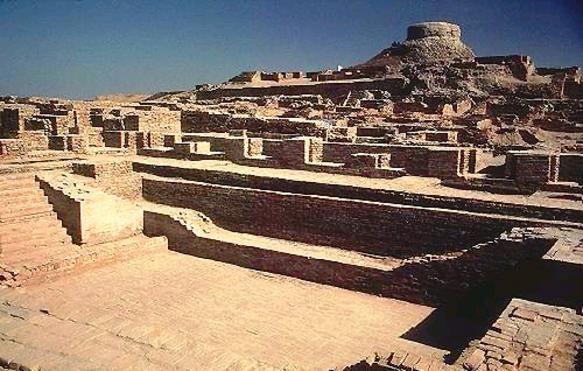
Mohanjo Daro, Lothal, etc.The city of Harappa is divided into two parts, with citadel on ground raised by filling it with mud and down below, the houses of common people. This pattern of settlement can be seen in other Harappan cities also. On the basis of size and importance of houses, we can understand that there were different classes among the people. A large granary found in Harappa gives evidence of the control of resources exercised by the society.
Mohanjo daro is situated in the Larkana district of Sind. This city on the banks of the Indus river is the biggest city in the Harappan culture. A special feature of this city is the Great Bath. The remains of a wharf found in Lothal in Gujarat give indisputable evidence of the foreign trade conducted by the people of this culture. Starting from Mandu in jammu in the north to the banks of the Narmada in the south and from Surkotda in the Makhran coast to Alamgirpur in Uttarpradesh in the east, the Harappan culture was spread across over an area of more than one lakh square kilometres.

Great Bath


Distinct from the other cities of the ancient world, town planning is a unique feature of the Harappan cities.
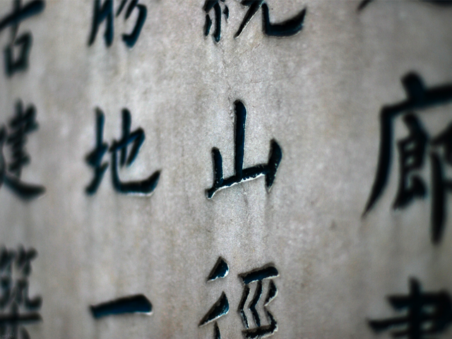
The other features of these cities were streets cutting at right angles, buildings on both sides of the streets, covered drains, etc. The bricks were of a standard size with defined length, width and thickness. Standardized weights and measures was another feature. Numerous steatite seals give information about this civilization. Pictures and a script are seen on the seals.                                  
Harappan script has not yet been satisfactorily deciphered. Efforts are going on in several parts of the world to read them, with the help of advanced technology.
There were groups of many craftsmen in society apart from agriculturists. They included those working on conch shell and mother-of-pearl, metal workers, potters, brick makers, sculptors and weavers.Apart from agriculture, it was trade that sustained the civilization. Harappan cities had trade relations with places like Egypt, Mesopotamia, China, etc. These conclusions have been arrived at on the basis of Harappan seals and other artefacts recovered from Egypt and Mesopotamian cities.No clear picture is available regarding their political organisation. Different scholars hold different opinions on the subject.
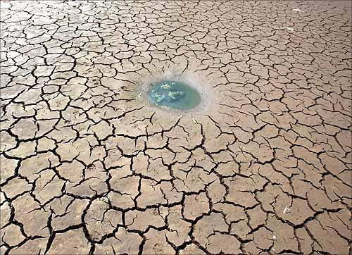
There are many theories about the end of the harappan civilization among historians.
Some of them are:
  • Heavy floods and earthquakes.
  • Rivers which changed their course and the drying up of the Ghaggar-Hakra river.
  • External invasion.
  • Changes in the environment.
  • Collapse of trade and commerce.

About the Pictorial script

Writing developed in China during the period between 3000-1600 B.C.The writing script developed at that time is called the Pictorial Script.In this script the pattern was that one sign stood for one word.The script was written from top to bottom.This script was called Pictorial because Pictorial means 'expressed by pictures'.


Monday 15 December 2014

Top 5 survey sites without investment

According to my experience i am listing the top 5 survey sites without investment


1.TOLUNA


Toluna is one of the leading survey sites across the world.We can earn points through completing surveys, completing profile surveys, voting, commenting etc.

2.SURVEYSAVVY


Luth Research found SurveySavvy in 1999. One of the best site which pay very high for every completed paid survey. Not only you get paid for participating in online survey but also when you refer your family and friends to join SurveySavvy.


3.PANNELSTATION

The Panel Station is essentially a community of consumers that shares its views and opinions about a variety of products and services via online market research surveys. The Panel Station focuses on customers from emerging economies like Brazil, Russia, India, China and Mexico. You can withdraw cash after your account reaches 1000 points.


4.POINTS2SHOP


Points2shop is a Top Genuine Paying Survey Site in which Users From Different Countries Can Participate.Earn Points By Completing Different Offers and by Completing Surveys.Win Prizes and Redeem Points For Gifts.You Can Win Awesome Prizes at Points2Shop worth lots of Money.The Top Feature of Points2shop is to Withdraw your Payment as Per Your Choice.


5.IPSOS


Ipsos is a Very Famous Online Survey Community Where You can Take Part in Survey Depending upon Your Profile.Register Yourself at Ipsos and Take Surveys and Earn Money Onilne From For Free without paying any fees.Share Your Opinion with Different People all across the World and Earn Incentives which can be Redeemed for Gifts or Cash.

How to deactivate facebook account?

Select the settings from facebook
After that select security from the left side the new window
In the security option you can see Deactivate your account atlast of  the option
That's all

Sunday 18 May 2014

ACCESS POINT NAMES OF ALL DATA CARDS IN INDIA

For connecting to internet using data cards we need access points name of that sim operator.So i am listing below some access point names of some data cards that in India:
Reliance
rcomnet or smartnet
Airtel
airtelgprs.com
T24
T24.internet
Aircel
aircelgprs
Idea
internet
BSNL
bsnlnet